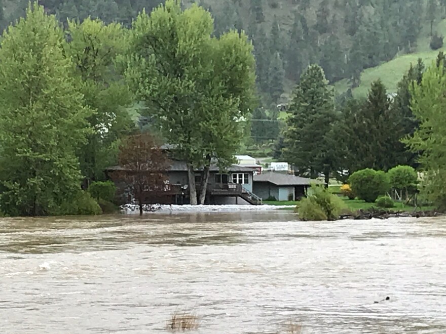
The flooding Clark Fork River at Missoula is forecast to hit just over 14 feet by tomorrow afternoon. It’s then expected to settle down - but not for long.
Fourteen feet is territory not seen on the Clark Fork in over 40 years. The raging river has already prompted mandatory evacuations for about 60 homes.
Flooding is now also being reported in East Missoula, according to Assistant Rural Fire Chief Travis Wafstet.
“In the area of the Sha Ron Fishing access, which is right at the corner of Speedway and Highway 200 at the bottom of Brickyard Hill, we’ve seen increased flow in the river over the last 24 hours. There’s about 3 or 4 homes right in that area that have begun to flood. Residents are getting water into their basements."
Missoula County Incident Command spokesman, Mel Holtz, says the power of these flooding rivers cannot be underestimated. Debris like trees – even several trailers swept from their foundations on Schmidt Road -- presents a significant danger.
“Those trailers broke apart, and some of that is lining some of the banks along that area," Holz says. "In addition, some outbuildings are also headed downstream, and believed to be a propane tank, as well that headed down the stream.”
So what’s next for the Clark Fork after it crests at 14 feet tomorrow? Smith says the current cool weather will help a little bit.
“We’ll actually see the waters subside slightly. We’re still going to remain in major flood stage for the first part of next week, but we’ll probably see them subside about a foot or so. But with the nice warm temperatures we’re anticipating for the first part of next week, the waters are anticipated to steadily increase again.”
Those "nice warm" temperatures Smith mentioned? Expect highs from the mid to upper 70s under clear skies. Great spring weather, if it weren’t for the fact that it’s going to peel off even more of the water in the mountain snowpack and send it shooting down into – you guessed it - Montana’s river basins.
Flood warnings and watches are in effect across our listening area. A river Flood Warning means flooding is expected to impact people and property in the warned area, according to the National Weather Service.
In north-central Montana, a flood warning is in place for the Sun River near Simms where recent rainfall combined with snowmelt is causing significant rises on the Sun River which will cause the river to reach flood stage sooner than expected.
There’s another warning in place through the weekend for flooding on the Smith River across Central Cascade County as runoff from snow and rain work their way into the river.
A Flood Warning continues for the Musselshell River near Harlowton, Lavina and Shawmut affecting Wheatland and Golden Valley Counties. Moderate flooding in the area is already occurring and will continue into next week. Be prepared for flooded roads along the Musselshell.
Near Missoula, the Bitterroot River’s current flooding is at over 12 feet, and farmland and some roads along the Bitterroot River from Lolo to the confluence with the Clark Fork river can expect possible flooding.
Another Flood Warning is in place for the Clark Fork River above Missoula and near Plains in south central Sanders County where the river is predicted to rise to over 16 feet by Sunday, affecting adjacent county roads.
An additional Flood Warning for the Clark Fork at St. Regis in Southeastern Mineral County and the Clark Fork near Drummond in Missoula and Granite counties is in effect until further notice. Some buildings have already flooded between Drummond and Bearmouth.
A Flood Warning continues for the Shields River near Livingston affecting Park County until Monday evening.
A Flood Warning is also in place for the Blackfoot River near Bonner in Missoula County where the river is expected to remain above 11 feet through at least Monday with minor flooding expected.
The National Weather Service in Great Falls has continued the Flood Warning until further notice for the Big Hole River near Melrose where the river is expected to remain at or above flood stage into next week.
The vicinity of Seeley Lake and the Clearwater river also have a warning in effect with minor flooding along Placid Lake Road south of Seeley Lake, as well as Boy Scout Road, C Street, and homes around Morrell Creek adjacent to Seeley Lake.
A flood warning remains in effect near Helena. Areas include Tenmile Creek in the Helena Valley, Prickly Pear Creek north of York Road in the Helena Valley, Mid Canyon Fishing Access, south of Dearborn on the Missouri River the Lincoln area, including locations on the Blackfoot River, Good News Lane and Stemple Pass Road. Some roadways are closed because of the flooding.
More information on flood watches and warnings across Montana.


